Thursday, March 24, 2011

Two Great Books

Two great books that I've been reading lately are:
  1. Microsoft Silverlight 4 and SharePoint 2010 Integration by Packt Publishing 
  2. Expert Python Programming by Packt Publishing
I don't work for Packt nor am paid to promote any of these books.  I just like the way the material is presented.  I find the books easy to read, information is presented in a meaningful way, and the material/examples are top notch.

These are two resources any programmer should have on the old bookshelf, or in the e-reader.

Monday, March 21, 2011

Geoprocessing Data types for Web Clients

From the Esri's Dev Summit 2011:

Friday, February 25, 2011

Getting a File Extension

Here is a useful bit of code to get the file extension of a file. The os module has a useful built in function called splitext(), which returns a string array where the 2nd entry is the file extension.

From Python.org:
Split the pathname path into a pair (root, ext) such that root + ext == path, and ext is empty or begins with a period and contains at most one period. Leading periods on the basename are ignored; splitext('.cshrc') returns ('.cshrc', '').

Enjoy
~A


def __fileExtension(filePath):
import os
return os.path.splitext(filePath)[1]
Wednesday, February 2, 2011

Map Scale and Resolution

When I first started using GIS, I did not program and I did not write any custom code.  I was a cartographer many years ago.  As I move on in my career I have slowly moved away from cartography, but the principles I learned in my cartography classes have been critical to my success as a developer.  When I saw this blog post it brought back a time when I use to just be a map maker (cartographer).  If you program in the GIS world, no matter if it's web, desktop, or services, you should always have a good understanding of how to present data.  Developing tools to show and analyze data is just one part of GIS, but in reality it's how you interpret/display the results that really matter.

So read up on this article because understanding Map Scale and Resolution is important to being a good GIS programmer.

I shall step off the soapbox now.

Friday, January 7, 2011

Developer Guidelines for Python

For anyone getting heavily involved with python development or wants to start getting involved with python, I recommend you follow the PEP-8 specs outlined on http://www.python.org/.  It's a simple enough programming style that I find allows for easy cooperation between developers. 

If that isn't good enough for you to follow, it's also the official develop style of the programming language. 

So check it out, and improve your python skills today: http://www.python.org/dev/peps/pep-0008/

Enjoy

Wednesday, January 5, 2011

TIGER Data Download Frenzy

It's here, so go get it.  The TIGER data is ready to go! Get it here.

Enjoy

Friday, December 3, 2010

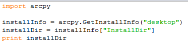
Getting Installation Information in ArcGIS 10

At v10 there is a very Arcpy way of getting the installation directory for ArcGIS Desktop.  It's very easy and it goes as follows:

Now we want to see what software is installed on the machine:

You'll ge a list of software installed on the machine.

Happy Coding!