Thursday, February 12, 2015

Check out ago-assistant

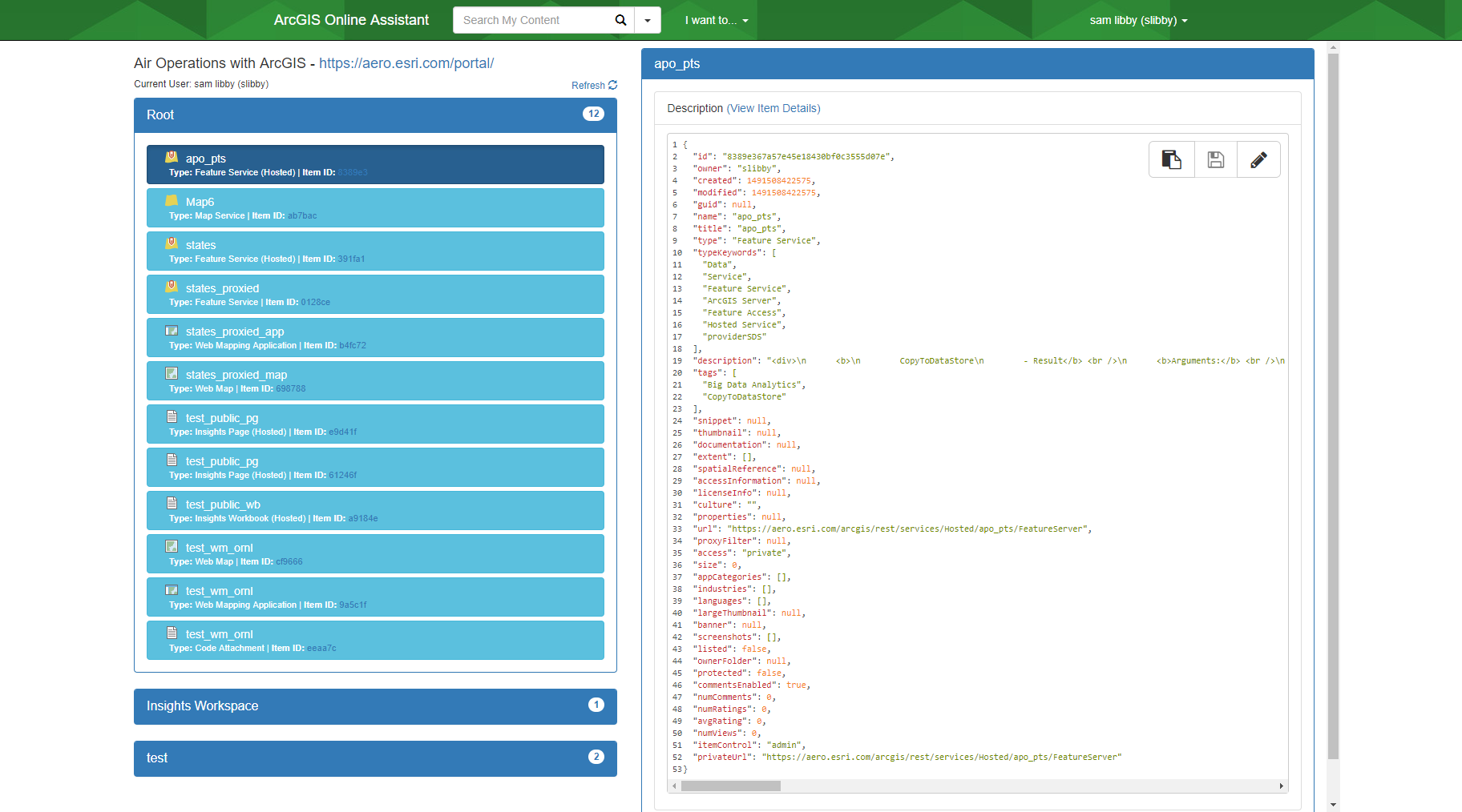
Ever want to get into the nuts and bolts of AGOL or Portal and see the JSON behind the scenes?  Well check out ago-assistant.

This application was developed by a follow co-worker, and it's awesome!  It's a nice GUI based application that gives you fine grained access to your site's information.


I find this tool coupled with fiddler can help you easily debug your applications, or better help you understand the ArcGIS REST API that performs the magic.

You can grab it from github here: https://github.com/Esri/ago-assistant

Enjoy and check it out.

A

Friday, January 9, 2015

Convert Runtime Database to File Geodatabase

New at 10.3, you can convert a runtime database to a file geodatabase.  The tool copies the contents of a runtime geodatabase into a new file geodatabase including the table names, etc...   It's very simple to use:

import arcpy
arcpy.CopyRuntimeGdbToFileGdb_conversion(r"D:\data\RuntimeGDBs\delta.geodatabase", 
                                         'D:\data\copiedGDBs\deltaFGDB.gdb')


Here we copied a .geodatabase file (runtime database) to a file geodatabase.  Now the data captured in the runtime db can be used in desktop or anything else that can't directly access runtime libraries.

Enjoy

Monday, December 22, 2014

Converting PDF to TIFF (10.3) using ArcPy

New at 10.3, is a handy tool many of us in the GIS world have wanted for a long time.  That is converting geo-referenced PDFs to Tiff files.
The help describes this tool as:
Exports an existing PDF file to a Tagged Image File Format (TIFF). If the PDF has georeference information, the TIFF can be a GeoTIFF. These TIFFs can be used as a source for heads-up digitizing and viewing in ArcMap. Both GeoPDF and ISO standards of georeferenced PDFs are supported. 

It is very straight forward to use:

import arcpy
arcpy.PDFToTIFF_conversion(in_pdf_file="C:/temp/sample.pdf", 
                           out_tiff_file="C:/temp/sample.tif", 
                           pdf_password="", 
                           pdf_page_number="1", 
                           pdf_map="Layers", 
                           clip_option="NO_CLIP", 
                           resolution="250", 
                           color_mode="RGB_TRUE_COLOR", 
                           tiff_compression="LZW", 
                           geotiff_tags="GEOTIFF_TAGS")


For this sample, I just created a map with one of the AGOL imagery layers in a blank ArcMap layout and exported it to PDF with the GeoReference information embedded.  This creates a TIFF that can be used for additional spatial data in the ArcMap session.

Enjoy,

A

Monday, November 17, 2014

Workflow for Adding Files in Parts for Portal or ArcGIS Online

Python 2.7.5 is not very good at handling big files.  Actually it stinks especially if you need to upload them via a multi-part post.  There are many 3rd party solutions, but I found issues with both poster and requests with the tool belt add-in.  They simply didn't work.  Luckily for us, the folks who designed the AGOL/Portal REST API provided an alternative way of uploading large files.  The method is called Add Item Part.  The documentation can be found here: http://resources.arcgis.com/en/help/arcgis-rest-api/index.html#/Add_Item_Part/02r300000094000000/.

When trying to figure out how to use this function, you also need to read the Add Item method as well to get how Add Item Part should be used.  The workflow is as follows:
  1. Call Add Item with no data (file data) and pass in multipart=True along with the filename=.extension.
  2. Break the file into parts, but they must be over 5 MBs except for the last chunk which signals an end of file. (I break everything into 50 MB chunks because I don't want to perform tons of POST calls)
  3. Call Add Item Part by using a POST.  Pass in the parameters partNum, which is a unique integer from 1 to 10,000.  You must pass that in, or each part will be overwritten.  Also, pass in the file via multi-part POST.
  4. Now call Commit function to tell the server, hey I'm done.  This is an asynchronous call, so don't forget to check the item's status before moving on, or you will not be able to update the item's properties.
    • If you look at your 'My Content' page on AGOL, you'll notice and item with everything stated as 'null' for the title, type, etc.. All you can do is delete the item right now.  This makes step 5 very important
  1. Update the item using the updateItem REST call.  Here we state the type, title, tags, etc.. all the good stuff you need to know so users can access the data.  

Great now we have the item in AGOL or Portal.  Simple right?  Not really, but it's a great way to get around Python's 2.7.5 annoying memory issue.  I haven't tested this on x64 python or python 3.4.  Hopefully some of my readers will post a comment letting me know if the memory issues with StringIO/cStringIO still exist when performing large file POSTs.


The add item part is in ArcREST today!

Get ArcREST: http://www.github.com/Esri/ArcREST
Also vote for my idea for a GUI builder for Python Add-Ins.

Monday, October 13, 2014

Searching for User Content on AGOL Using ArcREST

ArcGIS Online (AGOL) and Portal organizations are great, but managing the whole organization's content can be tough.  Here is a brief example on how you could search an site (in our case AGOL) and look at what a given user has shared publicly.

Searching is fairly straight forward, and do not require any security logins to perform.  You can see this by just going to www.arcgis.com and typing something into the search box.  For this example though, I am going to use login credentials just in case I needed to perform an administrative task down the line.
if __name__ == "__main__":
    username = "MY USERNAME"
    password = "MY PASSWORD"
    url = "http://www.arcgis.com/sharing"
    proxy_url = None#"127.0.0.1" # for fiddler
    proxy_port = None#"8888" # for fiddler
    q2 = "owner:esri"
    securityHandler = arcrest.AGOLTokenSecurityHandler(username,
                                                       password,
                                                       proxy_port=proxy_port,
                                                       proxy_url=proxy_url)    
    admin = arcrest.manageagol.Administration(url=url, 
                                              securityHandler=securityHandler,
                                              proxy_url=proxy_url,
                                              proxy_port=proxy_port)    
    res = admin.query_without_creds( q=q2, start=1, num=1) # Want to find only public item on owner:esri
    items = []
    total = int(res['total'])
    steps = int(total / 100)
    if (total % 100) > 0:
        steps += 1
    step = 1
    while step <= steps:
        res = admin.query_without_creds( q=q2, start= 1 + ((step-1)*100), num=100)
        for r in res['results']:
            print r # do something with item!
            del r
        del res
        step += 1    

The item is returned from the query_without_creds() as a dictionary.  It contains information about each item that is unique to that item.

The script isn't doing much with the items that it finds, but it does show how you can loop through the owner's items (esri).  If you could administer the owner's item, you could change those public items to private.

To get a better sense of what you cannot and can query, and how the syntax works, I would check out this (http://doc.arcgis.com/en/arcgis-online/reference/search.htm).  It shows the advanced search syntax in great detail.

You can get ArcREST here (www.github.com/esri/ArcREST) if you do not have it.

Happy searching!

Thursday, October 9, 2014

Using ArcREST to Export Hosted Feature Services

THIS POST IS FOR RELEASE ARCREST 2.0 AND WILL NOT WORK PERFECTLY FOR ARCREST RELEASE 3.0.

When you upload a feature class to ArcGIS Online (AGOL), you have the option to publish those feature classes. Now let's assume you have enabled editing on that data set. The question is how do you pull down the data so you can have an updated version in office? Well luckily for us, you have ArcREST to automate this task! ArcREST can be found here (www.github.com/Esri/ArcREST) if you do not have it.

This example will show how to automate the download of a hosted feature class as a shapefile to a centralized storage location.

The workflow is as follows:

  1. Connect to the AGOL site
  2. Export the item to a shapefile
  3. Download the item to disk
  4. Erase the exported item

import arcrest
import uuid
import os
import time
#   Inputs
#
itemID = "THE ITEM ID TO EXPORT"
username = "SOME USERNAME"
pw = "MY PASSWORD"
url = "http://www.arcgis.com/sharing"
filePath = r"c:\temp"
#   Logic
#
#  Create security handler
shAGOL = arcrest.AGOLTokenSecurityHandler(username, pw)
#  Connect to AGOL
org = arcrest.manageagol.Administration(url=url, securityHandler=shAGOL)
# Grab the user's content (items)
content = org.content  
usercontent = content.usercontent(username=username)
#  Create a export item with a random name using UUID
#  and export it to a zipfile
#
result =  usercontent.exportItem(title="%s" % uuid.uuid4().get_hex(),
                                     itemId=itemID,
                                     exportFormat=exportDataAs,
                                     exportParameters=None)

exportedItemId = result['exportItemId']
jobId = result['jobId']
exportItem = content.item(itemId=exportedItemId)
#   Ensure the item is finished exporting before downloading
#
status =  usercontent.status(itemId=exportedItemId, jobId=jobId, jobType="export")
    
while status['status'].lower() == "processing":
    time.sleep(3)
    status =  usercontent.status(itemId=exportedItemId,
                                 jobId=jobId,
                                 jobType="export")
filePath = exportItem.itemData(f="json", savePath=filePath)
#   Erase the exported item to clean up
#   AGOL
#
usercontent.deleteItems(items=exportItem.id)
del exportItem
print 'finishe!'

So what we have is a quick little script that downloads a file to the temp folder.  The key thing to look at is the while part of the code.  When perform actions like publish, generateFeatures, export, and createService, they are performed asynchronously on the system.  This means that you need to check if they are finished before performing further actions on the items.  The status method returns a dictionary of values, and you need to ensure that the value is not equal to 'processing', or any further actions like itemData() will return invalid information or data.  In the case of the itemData() you will download an empty zip file.

Enjoy and happy coding.
Monday, September 15, 2014

Using ArcPy to Determine the Underlying Database

Sometime you need to you what the underlying database is because you do not know what the database is.  I know it sounds strange, but it does happen.  I created a small script to solve this problem.

import arcpy
def checkDBType(dbPathOrConnectionFile):
    """ checks the db to get the database type """

    if dbPathOrConnectionFile.lower().endswith(".mdb"):
        return "PGDB"
    elif dbPathOrConnectionFile.lower().endswith(".gdb"):
        return "FGDB"
    elif dbPathOrConnectionFile.lower().endswith(".sde"):
        queries = {
            "Informix" : """select first 1 dbinfo("version", "full") from systables;""",
            "MSSQLServer" : """SELECT @@VERSION""",
            "Oracle" : """select * from v$version""",
            "PostGreSQL" : """select version()::varchar(255);"""
            }
        fail = True
        conn = arcpy.ArcSDESQLExecute(dbPathOrConnectionFile)
        for k,v in queries.iteritems():
            try:
                conn = arcpy.ArcSDESQLExecute(dbPathOrConnectionFile)
                conn.execute(v)
                return k
            except:
                pass
    return "Unknown"
Basically script just a tries the SQL snippet and it it works, then that is the database you are using. To run the sql statement, you use the arcpy.ArcSDESQLExecute()'s connection object which has a function called execute().

The results seem to be promising, but I didn't have an Informix DB to test this on. So if you have one, please let me know if that statement will work! Oracle, SQL Server and PostGreSQL all work well.

 Enjoy